Skip to content

Pāuatahanui - The Name

What does Pāuatahanui mean?

Establishing the meaning of the name has been a challenge, partly related to its spellingthere have been over 18 variations of the spelling since its creation as a written word. Furthermore, the presence or absence of a macron (the mark above a letter such as ā or ō) changes the meaning of a word. So ‘taha’ refers to the edge of something but ‘tahā-nui’ means a large calabash. The version we use today, with a macron over the first ‘a’ only, is the one most recently agreed to by Te Taura Whiri i te Reo Māori, the Māori Language Commission.

With this spelling, the Commission suggests that Pāuatahanui could mean a large calabash for storing pāua; or a large shellfish; or a fish hook with a piece of pāua shell inserted to attract fish; or even a variety of large kumara.


It’s also possible to break down Pāuatahanui into three separate words:

‘pāua’ – Māori for the well loved shellfish (possibly referring to the overall shape of the Inlet);

‘taha’ – Māori for side or edge;

‘nui’ – Māori for large.


The map pictured top right is from 1846 and uses the name in this way – broken into its three parts.

In combination, these Māori words could refer to the larger of two streams that flow into the Inlet at its eastern edge.


1846 map of Wellington war sites around Pāuatahanui

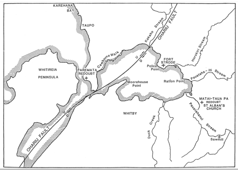
Ref: ‘1846 map of Wellington war sites around Pāuatahanui’.

From James Cowan, The New Zealand Wars vol 1 (NZETC website).

https://nzhistory.govt.nz/media/photo/1846-map-wellington-war-sites-around-pauatahanui.

(Ministry for Culture and Heritage), updated 2-Apr-2019


As the map pictured bottom right shows, the Pāuatahanui stream passes to the south of the original Matai-taua pā that was established by Te Rangihaeata and where St Albans church now stands. The stream enters the Inlet at its easterly edge.

In contrast, a smaller stream located to the north of the pā has, on this map, been labelled Pāuataha-iti. ‘iti’ is the Māori word for small.

This stream also enters the eastern edge of the Inlet, in this case near Ration Point, and coincides with the stream known today as Ration Creek. It may have received this name change after Ration Point became significant as a location where boats were moored while delivering provisions to the solders involved in building local roads.


This map is from the Journal of the Royal Society of New Zealand 1990* and includes labels that were given by Joseph Boulton who established the first hotel in the village in 1847.


With both streams identified in this way, it seems possible that the larger stream would have given its name to the Inlet and thus the village as well.

Pāuatahanui Inlet and outer part of Porirua Harbour